


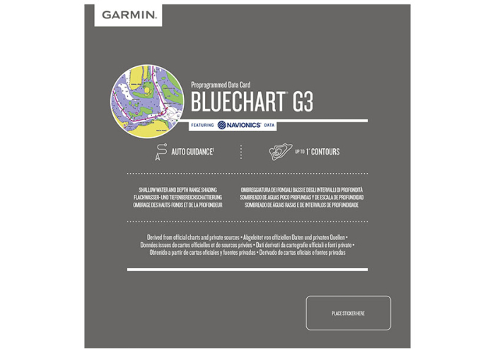
Garmin BlueChart G3 Coastal Charts AU,NZ


Garmin BlueChart g3 Australia and New Zealand Coastal Charts [HXPC024R]
(Garmin 010-C1020-20)
- Genuine Australian Garmin Warranty
- Peace of Mind Purchase Guarantee (bottom of page)
- Auto Guidance Technology
- Depth Range Shading
- Detailed Contours
- Shallow Water Shading
Overview
Experience unparalleled coverage and brilliant detail when you’re on the water with charts that feature integrated Navionics® data, Auto Guidance technology¹ and more.
Unparalleled Coastal Chart Coverage
- Provides exceptional coverage, clarity and detail with coastal charts that feature integrated Garmin and Navionics® data
- Auto Guidance¹ technology calculates a route using your desired depth and overhead clearance and provides a suggested path to follow.
- Includes depth range shading for up to 10 depth ranges, enabling you to view your target depth at a glance
- Up to 1’ contours provide a more accurate depiction of the bottom structure for improved fishing charts and navigation in swamps, canals and marinas.
Auto Guidance Technology
Whether you are fishing or cruising, select a spot, and get a route showing you the general path and nearby obstructions at a safe depth1.
Depth Range Shading
This feature displays high-resolution depth range shading for up to 10 depth ranges so you can view your designated target depth.
Detailed Contours
BlueChart g3 charts feature 1’ contours that provide a more accurate depiction of bottom structure for improved fishing charts and enhanced detail in swamps, canals and port plans.
Shallow Water Shading
To aid in navigation, Shallow Water Shading allows map shading at a user-defined depth to give a clear picture of shallow waters.
¹Auto Guidance is for planning and does not replace safe navigation practices. Auto Guidance is not included in preloaded BlueChart g3 for ECHOMAP™ Plus series chart plotters
This Garmin Map is compatible with the following devices:
| Alpha® 200, Handheld Only | GPSMAP® 64x |
| Alpha® 200i | GPSMAP® 65 |
| Colorado® 400c | GPSMAP® 65s |
| echoMAP™ 45dv | GPSMAP® 66i |
| echoMAP™ 70dv | GPSMAP® 66s |
| echoMAP™ 75sv | GPSMAP® 66sr |
| echoMAP™ CHIRP 95sv | GPSMAP® 66st |
| ECHOMAP™ Plus 45cv | GPSMAP® 7407xsv |
| ECHOMAP™ UHD 65cv | GPSMAP® 751xs |
| ECHOMAP™ UHD 75cv | GPSMAP® 752xs |
| ECHOMAP™ UHD 75sv | GPSMAP® 752xs Plus |
| ECHOMAP™ UHD 95sv | GPSMAP® 753xsv |
| ECHOMAP™ UHD2 5" Chartplotters 55cv Without Transducer | GPSMAP® 78 |
| ECHOMAP™ UHD2 7" Chartplotter | GPSMAP® 78s |
| Echomap Ultra 105sv with GT56UHD-TM | GPSMAP® 78sc |
| ECHOMAP™ Ultra 125sv, With GT56UHD-TM Transducer | GPSMAP® 79 Series |
| GPSMAP® 1020xs | GPSMAP® 8008 MFD |
| GPSMAP® 1022xsv | GPSMAP® 8015 MFD |
| GPSMAP® 1222xsv | GPSMAP® 8410xsv |
| GPSMAP® 1222xsv Plus | GPSMAP® 8412xsv |
| GPSMAP® 1222xsv Touch | GPSMAP® 8416xsv |
| GPSMAP® 1253xsv | GPSMAP® 8417 MFD |
| GPSMAP® 276Cx | GPSMAP® 8422 MFD |
| GPSMAP® 450/450s | GPSMAP® 8424 MFD |
| GPSMAP® 495 | GPSMAP® 8500 Black Box |
| GPSMAP® 551 | GPSMAP® 86i |
| GPSMAP® 551s | GPSMAP® 86s |
| GPSMAP® 556 | GPSMAP® 8700 Black Box |
| GPSMAP® 556s | GPSMAP® 952xs Plus |
| GPSMAP® 557xs | GPSMAP® 953xsv |
| GPSMAP® 62s | Montana® 650t |
| GPSMAP® 62sc | Montana® 700 |
| GPSMAP® 64 | Montana® 700i |
| GPSMAP® 64csx | Montana® 750i |
| GPSMAP® 64s | Oregon® 700 |
| GPSMAP® 64st | Oregon® 750t |
| GPSMAP® 64sx | Rino® 750 |
Garmin - The Brand
Garmin is a leading worldwide provider of navigation, aviation, marine, outdoor, and fitness products. Garmin products are known for their innovative features, compelling design and quality that is second to none. Here we stock the latest range of these fantastic products and believe they are the best in their field, making us one of Australia's leading independent Garmin retailers.
MicroSD™/SD™ Card Requirements
Make sure your device is compatible with this product before purchasing. View limitations with some marine mapping products.
https://support.garmin.com/en-AU/marine/
To view and use the maps on this card, you must have a device with a microSD/SD card slot. Maps on a MicroSD/SD card require a unit to be viewed on a computer with BaseCamp™ or HomePort™, depending on the map type.
Reduced price map updates are not available for these cards. You must purchase a new card with the latest map data to update the maps.
The MicroSD/SD card package includes a microSD card and an SD card adapter.
COVERAGE
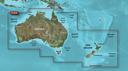
Detailed coverage of Australia, New Zealand and many associated islands. Coverage includes the Great Barrier Reef, Tasmania, Norfolk Island, Campbell Island, the Auckland Islands, the Antipode Islands, the Bounty Islands, the Chatham Islands and the Kermadec Islands. Ports include Sydney, Melbourne, Perth, Darwin and Cairns in Australia; Wellington, Auckland, Nelson and Dunedin in New Zealand and Port Moresby, Papua-New Guinea.

The information below is required for social login
Sign In
Create New Account